Understanding CartAGen data schema for generalization
CartAGen uses a centralized data schema to load and generalize geographic information, following the principles of multiple-representation databases (see Balley et al. 2004 for instance). This page explains how it works, describes the content of the centralized schema, and shows how to extend it if necessary.
- Date 22/06/2017.
- Author: Guillaume Touya
- Contact {firstname.lastname}@ign.fr.
What is CartAGen data schema for generalization?

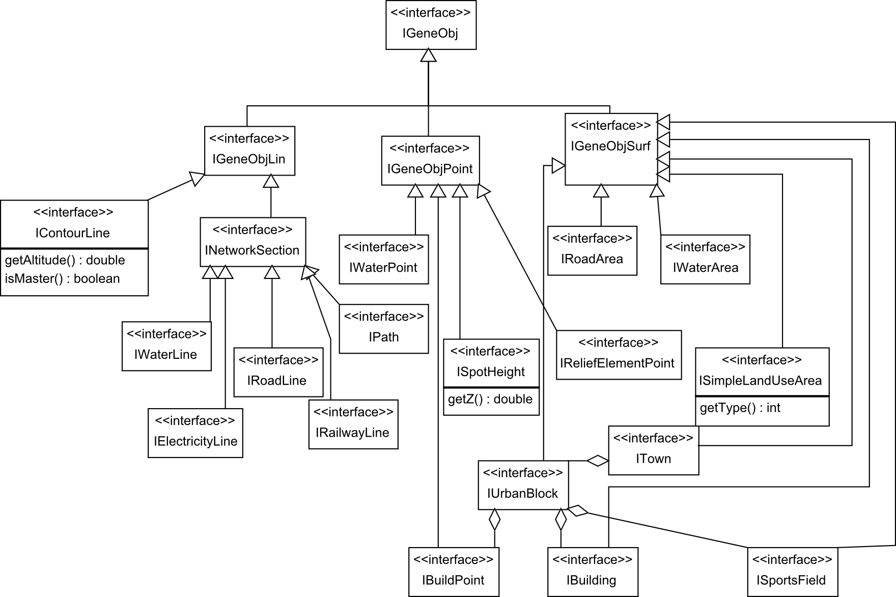
The figure above shows the main interfaces of the CartAGen centralized schema. Geographic objects stored in postGIS databases, shapefiles, .osm files are loaded as IRoadLine features for roads, IBuilding for buildings, IWaterLine for rivers, etc. All these interfaces extend a common IGeneObj interface that represent geographical feature that can be generalized. All the generalization processes in CartAGen deal with these generic IGeneObj features, so they can be applied to any kind of input data that can implement this centralized schema.
When a user wants to generalize its dataset with CartAGen, the difficulty is not be sure that the processes can use such data as input, but to make sure that the input data can be loaded into these centralized classes. Rather than coding new algorithms for new datasets that are not handled in CartAGen yet, only a new data loader is necessary!

IFeature is the GeOxygene version of the Simple Feature Class OGC/ISO standard. IFeature is an interface for objects that have a geometry and semantic attributes (that also follow the OGC/ISO standards). The geometry implementation uses the Java Topology Suite (JTS) library. The CartAGen interface IGeneObj is an extension of this IFeature interface, that contains specific method related to map generalization (see figure above).
One of the most common operators of map generalization is deletion/elimination, so IGeneObj features can be eliminated (without being removed from dataset, to be able to backtrack this elimination). The initial geometry is also stored in order to backtrack to the initial state, and to allow the use of preservation constraints that compare the current geometry with the initial one.
The method java void addToGeneArtifacts(Object artifact) allows the addition of artifacts useful for generalization, e.g. agents in multi-agent system.
GeOxygene features
The method java IFeature getGeoxObj() gives GeOxygene feature version of the CartAGen object, that are direct implementations of the OGC based IFeature interface. This alternate version of the feature might be useful to use to spatial analysis algorithms that exist in the GeOxygene platform on which CartAGen is based. For instance, the Strokes (Thomson & Richardson 1999) algorithm exists in GeOxygene for purposes larger than generalisation, and the GeOxygene feature version is used to trigger the Strokes algorithm for generalisation.
Description of the interfaces of the centralized schema
The figures below show with more details the centralized schema for the main topographic map themes that can be generalized. More information on the schema can be found in the Javadoc and in the comments in the code.
Administrative schema

Airport schema
Hydrography schema
Road schema
Implementations of the centralized schema
The schema described above is composed of Java interfaces for genericity. But in order to instantiate this schema, proper Java classes are necessary (an interface cannot be instantiated, it’s only a skeleton that the classes must respect).
There are two available implementations of the centralized schema:
- a default one that only implements the interfaces without any additional attribute,
- an OSM implementation that also stores raw tags and OSM metadata on each feature.
How to extend the centralized schema
This part of the tutorial explains how to extend the centralized schema when a type of feature you want to process does not exist in the schema yet. A use case based on OpenStreetMap (OSM) cycle ways illustrates here the different steps.
Add a new interface to the centralized schema
The first step is to check if there is an interface that models cycle ways in the CartAGen centralized schema. Now there is one existing, but let’s pretend there is none. We want to model cycle ways as a network, so the new interface has to extend the INetworkSection interface. If our new type of feature were a point feature, it would extend IGeneObjPoint, IGeneObjLin for line features not structured in networks, and IGeneObjSurf for polygon features.
The code below defines the new interface ICycleWay, whose fields are derived from common characteristics of OSM cycle ways: the cycle way surface and its width (named realWidth here to avoid confusions with the getWidth() method used in CartAGen to retrieve map symbol width).
public interface ICycleWay extends INetworkSection {

  /**
   * The getter for the surface of the cycle way, e.g. "paved" or "asphalt".
   * @return
   */
  public String getSurface();

  public void setSurface(String surface);

  /**
   * The getter for the real or "ground" width of the cycle way, different from
   * the getWidth method inherited from INetworkSection that gives the symbol
   * width.
   * @return
   */
  public double getRealWidth();

  public void setRealWidth(double width);
}
Implementing the new interface
We’ve seen above in this tutorial that the CartAGen centralized schema might have several implementations to deal with specific characteristics of some datasets (e.g. the OSM implementation allows to store the raw tags on each feature in addition to the fields already contained in the schema).
In order to actually load cycle ways, there has to be some implementation of the ICycleWay interface in the implementation that you are using (ideally, the interface should be implemented in all centralized schema implementations). in this use case, we select the OSM implementation and add the following class:
package fr.ign.cogit.geoxygene.osm.schema.roads;

import fr.ign.cogit.cartagen.core.genericschema.network.INetworkNode;
import fr.ign.cogit.cartagen.core.genericschema.road.ICycleWay;
import fr.ign.cogit.geoxygene.api.spatial.coordgeom.ILineString;
import fr.ign.cogit.geoxygene.osm.schema.network.OsmNetworkSection;

public class OsmCycleWay extends OsmNetworkSection implements ICycleWay {

  @Override
  public double getWidth() {
    // TODO Auto-generated method stub
    return 0;
  }

  @Override
  public double getInternWidth() {
    // TODO Auto-generated method stub
    return 0;
  }

  @Override
  public INetworkNode getInitialNode() {
    // TODO Auto-generated method stub
    return null;
  }

  @Override
  public void setInitialNode(INetworkNode node) {
    // TODO Auto-generated method stub
  }

  @Override
  public INetworkNode getFinalNode() {
    // TODO Auto-generated method stub
    return null;
  }

  @Override
  public void setFinalNode(INetworkNode node) {
    // TODO Auto-generated method stub
  }

  @Override
  public String getSurface() {
    // TODO Auto-generated method stub
    return null;
  }

  @Override
  public void setSurface(String surface) {
    // TODO Auto-generated method stub
  }

  @Override
  public double getRealWidth() {
    // TODO Auto-generated method stub
    return 0;
  }

  @Override
  public void setRealWidth(double width) {
    // TODO Auto-generated method stub
  }
It can be noticed that our new class extends OsmNetworkSection class that itself extends OsmGeneObj that implements common methods to handle OSM tags and metadata. So we add the following in the class declaration:
  private String surface;

  @Override
  public String getSurface() {
    return surface;
  }

  @Override
  public void setSurface(String surface) {
    this.surface = surface;
  }

  private double realWidth;

  @Override
  public double getRealWidth() {
    return realWidth;
  }

  @Override
  public void setRealWidth() {
    this.realWidth = width;
  }
Extended the factory of the chosen implementation
The centralized CartAGen schema is coded following the principles of the factory design pattern: we do not directly instantiate the implemented classes of the centralized schema, we use a factory to create new objects, the factory using the good implementation. Using this pattern, the generalization code is not dependant on the implementations. In the use case, the abstract factory needs to contain a createCycleWay(ILineString line) method and the OSM version of the factory extends this method by creating an OsmCycleWay instance, while the default factory creates a CycleWay instance.
So let’s start by adding one (or more) constructors within the OsmCycleWay class:
  public OsmCycleWay(ILineString line) {
    super();
    this.setGeom(line);
  }
Then, add the method that could use this constructor in the abstract factory (AbstractCreationFactory in package fr.ign.cogit.cartagen.core.genericschema) :
  @SuppressWarnings("unused")
  public ICycleWay createCycleWay(ILineString line) {
    AbstractCreationFactory.logger
        .error("Non implemented creation factory method for ICycleWay");
    return null;
  }
Then override this method in the OSM implementation factory (fr.ign.cogit.cartagen.osm.osmschema.OSMSchemaFactory) :
  @Override
  public ICycleWay createCycleWay(ILineString line) {
    return new OsmCycleWay(line);
  }
There is a final step, specific to OSM implementations because .osm files do not order, or classify the map features: a generic method that invokes the good factory method as to be completed with the case of a feature whose tags match with cycle ways.
	public OsmGeneObj createGeneObj(Class<?> classObj, OSMResource resource,
			Collection<OSMResource> nodes) {
		if (IRoadLine.class.isAssignableFrom(classObj)) {
			ILineString line = OsmGeometryConversion.convertOSMLine(
					(OSMWay) resource.getGeom(), nodes);
			return (OsmGeneObj) this.createRoadLine(line, 0);
		}

		...

	        if (ICycleWay.class.isAssignableFrom(classObj)) {
                        ILineString line = OsmGeometryConversion
                          .convertOSMLine((OSMWay) resource.getGeom(), nodes);
                         return (OsmGeneObj) this.createCycleWay(line);
                }
		// TODO
		return null;
	}
Creating a dedicated population in the dataset
In order to be stored and displayed in CartAGen, the features of the centralized schema have the be added in a dedicated population of features, the populations being stored in a CartAGenDataset instance. Each interface of the centralized schema has a dedicated population in the dataset and the name of the population is standardized as a static field in the CartAGenDataset class. Four additions are necessary in the CartAGenDataset class:
- add the population name as a static field :
public class CartAGenDataSet {

	// ///////////////////////////////////////
	// STANDARD NAMES OF DATASET POPULATIONS
	// ///////////////////////////////////////

	public static final String TREE_POINT_POP = "trees";
	public static final String CYCLEWAY_POP = "cycleWay";
- Complete the getPopNameFromObj(IFeature obj) method by adding the following condition:
    if (obj instanceof ICycleWay) {
      return CartAGenDataSet.CYCLEWAY_POP;
    }
- Complete the getPopNameFromClass(Class<?> classObj) method by adding the following condition:
    if (ICycleWay.class.isAssignableFrom(classObj)) {
      return CartAGenDataSet.CYCLEWAY_POP;
    }
- Finally, add a new shortcut method that allows a direct access to the cycle way features:
  /**
   * Gets the cycleways of the dataset
   *
   * @return
   */
  @SuppressWarnings("unchecked")
  public IPopulation<ICycleWay> getCycleWays() {
    return (IPopulation<ICycleWay>) this.getCartagenPop(
        CartAGenDataSet.CYCLEWAY_POP, ICycleWay.FEAT_TYPE_NAME);
  }
Displaying the new features
In order to display the newly added features, they have to be included in the data loading options, see the tutorial on data loading.
Then, once the layer is loaded, its display is encoded using the Styled Layer Descriptor (SLD/SE) OGC standard. SLD is standardized way of describing the map symbols (e.g. width and color of a line symbol).
You can find more information on SLD symbolization in this dedicated tutorial.
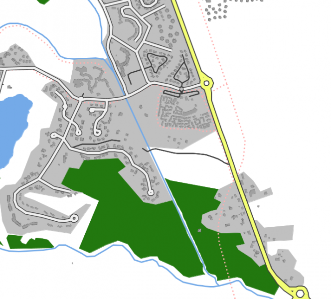
The following code is the SLD encoding that enables to mimic the standard OSM style of cycle ways (see image below).
  <NamedLayer>
    <Name>cycleWay</Name> <!-- this name corresponds to the layer name, i.e. the
    name of the CycleWay population (CartAGenDataSet.CYCLEWAY_POP) -->
      <UserStyle>
        <FeatureTypeStyle>
          <Rule>
            <Filter>
              <PropertyIsEqualTo>
              <PropertyName>highway</PropertyName>
               <Literal>cycleway</Literal>
              </PropertyIsEqualTo>
            </Filter>
          <LineSymbolizer>
            <Stroke>
              <CssParameter name="stroke">#D391BE</CssParameter>
              <CssParameter name="stroke-width">2.0</CssParameter>
              <CssParameter name="stroke-linejoin">round</CssParameter>
              <CssParameter name="stroke-linecap">round</CssParameter>
              <CssParameter name="stroke-dasharray">6 3</CssParameter>
            </Stroke>
          </LineSymbolizer>
        </Rule>
      </FeatureTypeStyle>
    </UserStyle>
  </NamedLayer>


